
North York Moors National Park topographic map
Interactive map
Click on the map to display elevation.
North York Moors National Park
As part of the United Kingdom, the North York Moors area generally has warm summers and relatively mild winters. Weather conditions vary from day to day as well as from season to season. The latitude of the area means that it is influenced by predominantly westerly winds with depressions and their associated fronts, bringing with them unsettled and windy weather, particularly in winter. Between depressions, there are often small mobile anticyclones that bring periods of fine weather. In winter, anticyclones bring cold dry weather. In summer, the anticyclones tend to bring dry settled conditions, which can lead to drought. For its latitude, this area is milder in winter and cooler in summer due to the influence of the Gulf Stream in the North Atlantic Ocean. Air temperature varies on a daily and seasonal basis. The temperature is usually lower at night and January is the coldest time of the year. The two dominant influences on the climate of the North York Moors are the shelter against the worst of the moist westerly winds provided by the Pennines and the proximity of the North Sea. Late, chilly springs and warm summers are a feature of the area, but there are often spells of fine autumn weather. Onshore winds in spring and early summer bring mists or low stratus clouds (known locally as sea frets) to the coasts and moorland. Within the area, variations in climate are brought about by local differences in altitude, aspect and shelter.
About this map
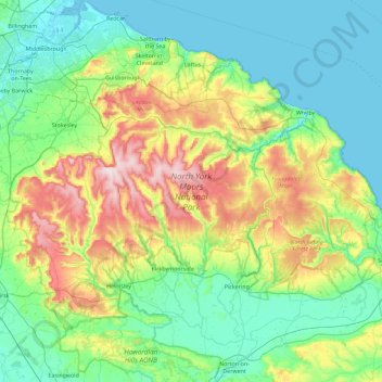
Name: North York Moors National Park topographic map, elevation, terrain.
Average elevation: 110 m
Minimum elevation: -3 m
Maximum elevation: 449 m
Other topographic maps
Click on a map to view its topography, its elevation and its terrain.