
Concrete topographic map
Interactive map
Click on the map to display elevation.
About this map
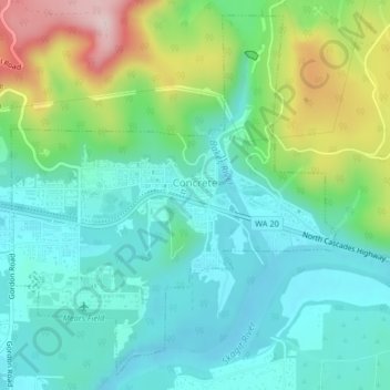
Name: Concrete topographic map, elevation, terrain.
Location: Concrete, Skagit County, Washington, United States (48.52557 -121.76615 48.55053 -121.73227)
Average elevation: 125 m
Minimum elevation: 42 m
Maximum elevation: 341 m
Mears Field (3W5), formerly known as Concrete Municipal Airport, is located one mile south of Concrete at an elevation of 267 ft MSL.
Other topographic maps
Click on a map to view its topography, its elevation and its terrain.
Mount Vernon
United States > Washington > Skagit County
Mount Vernon, Skagit County, Washington, 98273, United States
Average elevation: 37 m