
Imperia topographic map
Interactive map
Click on the map to display elevation.
About this map
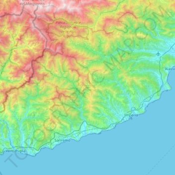
Name: Imperia topographic map, elevation, terrain.
Location: Imperia, Liguria, Italy (43.77569 7.49516 44.14102 8.13540)
Average elevation: 604 m
Minimum elevation: 0 m
Maximum elevation: 2,636 m
Other topographic maps
Click on a map to view its topography, its elevation and its terrain.
Cinque Terre
Cinque Terre, Vernazza, La Spezia, Liguria, 19010, Italy
Average elevation: 235 m
Monterosso al Mare
Italy > Liguria > Monterosso al Mare
Monterosso al Mare, SP, Liguria, 19016, Italy
Average elevation: 266 m