
Clutha District topographic map
Interactive map
Click on the map to display elevation.
About this map
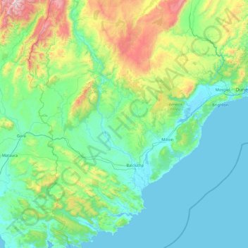
Name: Clutha District topographic map, elevation, terrain.
Location: Clutha District, Otago, New Zealand (-46.63865 168.99337 -45.43953 170.20361)
Average elevation: 276 m
Minimum elevation: -2 m
Maximum elevation: 1,808 m
Other topographic maps
Click on a map to view its topography, its elevation and its terrain.
Clydevale
New Zealand > Otago > Clutha District
Clydevale, Clutha District, Otago, 9247, New Zealand
Average elevation: 39 m
Wānaka
New Zealand > Otago > Queenstown-Lakes District
Wānaka, Queenstown-Lakes District, Otago, 9305, New Zealand
Average elevation: 381 m
Karitane Point
New Zealand > Otago > Dunedin City
Karitane Point, Dunedin City, Otago, 9510, New Zealand
Average elevation: 1 m
Milton
New Zealand > Otago > Clutha District
Milton, Clutha District, Otago, 9220, New Zealand
Average elevation: 55 m
Oamaru
New Zealand > Otago > Waitaki District
Oamaru, Waitaki District, Otago, 9444, New Zealand
Average elevation: 34 m
Glenorchy
New Zealand > Otago > Queenstown-Lakes District
Glenorchy, Queenstown-Lakes District, Otago, 9372, New Zealand
Average elevation: 384 m
Owaka
New Zealand > Otago > Clutha District
Owaka, Clutha District, Otago, 9535, New Zealand
Average elevation: 27 m
Mosgiel
New Zealand > Otago > Dunedin City
Mosgiel, Dunedin City, Otago, 9024, New Zealand
Average elevation: 55 m
Mount Selwyn
New Zealand > Otago > Queenstown-Lakes District
Mount Selwyn, Queenstown-Lakes District, Otago, New Zealand
Average elevation: 853 m
Ranfurly
New Zealand > Otago > Central Otago District
Ranfurly, Central Otago District, Otago, 9332, New Zealand
Average elevation: 429 m
Dunback
New Zealand > Otago > Waitaki District
Dunback, Waitaki District, Otago, New Zealand
Average elevation: 111 m
Blanket Bay
New Zealand > Otago > Queenstown-Lakes District
Blanket Bay, Queenstown-Lakes District, Otago, 9372, New Zealand
Average elevation: 337 m
Kingston
New Zealand > Otago > Queenstown-Lakes District
Kingston, Queenstown-Lakes District, Otago, New Zealand
Average elevation: 507 m
Maniototo Plain
New Zealand > Otago > Central Otago District > Maniototo Community
Maniototo Plain, Maniototo Community, Central Otago District, Otago, New Zealand
Average elevation: 409 m
Karitane
New Zealand > Otago > Dunedin City
Karitane, Dunedin City, Otago, 9510, New Zealand
Average elevation: 18 m
Dalefield
New Zealand > Otago > Queenstown-Lakes District
Dalefield, Queenstown-Lakes District, Otago, New Zealand
Average elevation: 475 m
Cromwell Community
New Zealand > Otago > Central Otago District
Cromwell Community, Central Otago District, Otago, New Zealand
Average elevation: 876 m
Matukituki River
New Zealand > Otago > Queenstown-Lakes District
Matukituki River, Queenstown-Lakes District, Otago, New Zealand
Average elevation: 337 m
Central Otago District
Central Otago District, Otago, New Zealand
Average elevation: 737 m
Queenstown
New Zealand > Otago > Queenstown-Lakes District
Queenstown, Queenstown-Lakes District, Otago, 9348, New Zealand
Average elevation: 592 m
Taipo
New Zealand > Otago > Waitaki District
Taipo, Waitaki District, Otago, 9495, New Zealand
Average elevation: 17 m
Dunedin
New Zealand > Otago > Dunedin City
Dunedin, Dunedin City, Otago, 9054, New Zealand
Average elevation: 110 m
Alexandra
New Zealand > Otago > Central Otago District > Vincent Community
Alexandra, Vincent Community, Central Otago District, Otago, 9320, New Zealand
Average elevation: 241 m
Queenstown-Lakes District
Queenstown-Lakes District, Otago, New Zealand
Average elevation: 832 m