
Oakdale topographic map
Interactive map
Click on the map to display elevation.
About this map
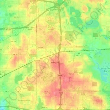
Name: Oakdale topographic map, elevation, terrain.
Location: Oakdale, Washington County, Minnesota, 55128, United States (44.94869 -92.98489 45.03405 -92.93409)
Average elevation: 302 m
Minimum elevation: 262 m
Maximum elevation: 335 m
Other topographic maps
Click on a map to view its topography, its elevation and its terrain.
Forest Lake
United States > Minnesota > Washington County > Forest Lake > Forest Lake
Forest Lake, Washington County, Minnesota, 55025, United States
Average elevation: 277 m
Forest Lake
United States > Minnesota > Washington County
Forest Lake, Washington County, Minnesota, 55025, United States
Average elevation: 279 m