
Schöneberg topographic map
Interactive map
Click on the map to display elevation.
About this map
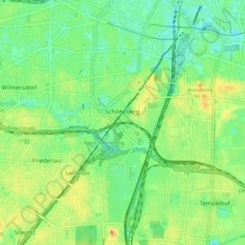
Name: Schöneberg topographic map, elevation, terrain.
Location: Schöneberg, Tempelhof-Schöneberg, Berlin, Germany (52.45464 13.33629 52.50494 13.37656)
Average elevation: 46 m
Minimum elevation: 32 m
Maximum elevation: 64 m
Other topographic maps
Click on a map to view its topography, its elevation and its terrain.