
Cobb topographic map
Interactive map
Click on the map to display elevation.
About this map
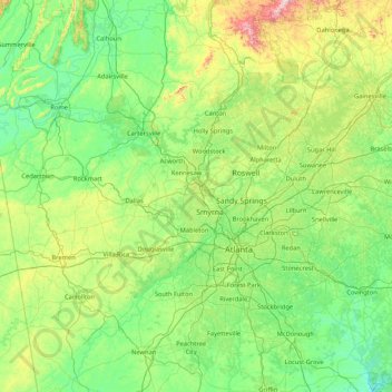
Name: Cobb topographic map, elevation, terrain.
Location: Cobb, Georgia, 30060, United States of America (33.23739 -85.27320 34.63739 -83.87320)
Average elevation: 299 m
Minimum elevation: 126 m
Maximum elevation: 1,099 m
Other topographic maps
Click on a map to view its topography, its elevation and its terrain.
Ringgold
United States of America > Georgia > Ringgold
Ringgold is situated in the Valley and Ridge geologic province of the Appalachian Mountains, characterized by long north-northeasterly trending ridges separated by valleys. The topography was formed by the erosion of alternating layers of hard and soft sedimentary rock that were folded and faulted during the…
Average elevation: 268 m
Brunswick
United States of America > Georgia > Brunswick
The city is the lowest in the state of Georgia, with an elevation of only 10 to 14 feet (3.0 to 4.3 m) above sea level. According to the U.S. Census Bureau, Brunswick's land area is 32.4 square miles (83.8 km2). Its total area is 42.4 square miles (109.8 km2); 10.0 square miles (26.0 km2) of this is water.
Average elevation: 2 m