
Ceres topographic map
Interactive map
Click on the map to display elevation.
About this map
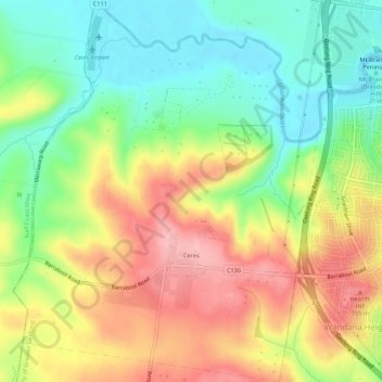
Name: Ceres topographic map, elevation, terrain.
Location: Ceres, City of Greater Geelong, Victoria, 3221, Australia (-38.18381 144.25048 -38.14127 144.29367)
Average elevation: 87 m
Minimum elevation: 18 m
Maximum elevation: 170 m
Victoria trails, hiking, mountain biking, running and outdoor activities
Other topographic maps
Click on a map to view its topography, its elevation and its terrain.