
Make a donation
Gear up for your next adventure:
As an Amazon Associate, this site earns from qualifying purchases at no extra cost to you.
Mount Observation topographic map
Click on the map to display elevation.
Make a donation
Gear up for your next adventure:
As an Amazon Associate, this site earns from qualifying purchases at no extra cost to you.
About this map
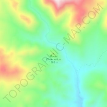
Name: Mount Observation topographic map, elevation, terrain.
Location: Mount Observation, Washoe County, Nevada, United States (41.04568 -119.36024 41.04578 -119.36014)
Average elevation: 1,580 m
Minimum elevation: 1,421 m
Maximum elevation: 1,854 m
Make a donation
Gear up for your next adventure:
As an Amazon Associate, this site earns from qualifying purchases at no extra cost to you.
Other topographic maps
Click on a map to view its topography, its elevation and its terrain.
Moapa Valley
United States > Nevada > Clark County
Moapa Valley is at an elevation of 1,265 ft (386 m) above sea level. The United States Census Bureau gives the census-designated place (CDP) of Moapa Valley (which may not coincide exactly with the town boundaries) a total area of 43.7 square miles (113.2 km2), of which 43.7 square miles (113.1 km2) is land…
Average elevation: 520 m
Make a donation
Gear up for your next adventure:
As an Amazon Associate, this site earns from qualifying purchases at no extra cost to you.
Carson City
Most of the city proper resides in the Eagle Valley. The Carson River flows from Douglas County through the southwestern edge of both the valley and Carson City. Since the consolidation, the city limits today include several small populated areas outside of this valley. Today the city limits include several…
Average elevation: 1,825 m