
Lower Township topographic map
Interactive map
Click on the map to display elevation.
About this map
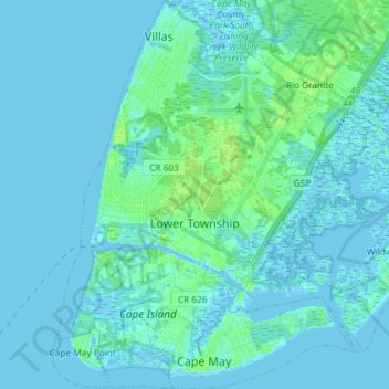
Name: Lower Township topographic map, elevation, terrain.
Location: Lower Township, Cape May County, New Jersey, United States (38.92547 -74.97771 39.03926 -74.83087)
Average elevation: 2 m
Minimum elevation: -5 m
Maximum elevation: 11 m
Other topographic maps
Click on a map to view its topography, its elevation and its terrain.
Jarvis Sound
United States > New Jersey > Lower Township
Jarvis Sound, Lower Township, Cape May County, New Jersey, 080204, United States
Average elevation: 0 m