
Minden topographic map
Interactive map
Click on the map to display elevation.
About this map
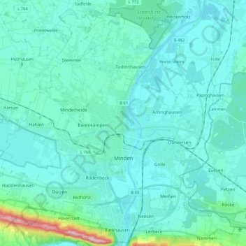
Name: Minden topographic map, elevation, terrain.
Location: Minden, Kreis Minden-Lübbecke, North Rhine-Westphalia, Germany (52.24706 8.79206 52.36487 8.99831)
Average elevation: 60 m
Minimum elevation: 34 m
Maximum elevation: 262 m
The lowest part of the town is in the district of Leteln, at 40 metres (131 feet), while the highest part is in the district of Haddenhausen at 181 metres (594 feet). The altitude of the town is given officially as 42.2 metres (138.5 feet), based on the elevation of the town hall.
Other topographic maps
Click on a map to view its topography, its elevation and its terrain.
Straußberg
Germany > North Rhine-Westphalia > Kreis Minden-Lübbecke > Lübbecke
Straußberg, Lübbecke, Kreis Minden-Lübbecke, North Rhine-Westphalia, 32609, Germany
Average elevation: 176 m