
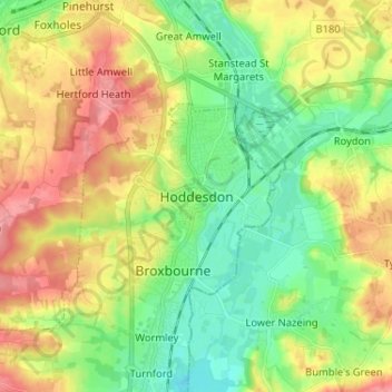
Hoddesdon topographic map
Interactive map
Click on the map to display elevation.
About this map
Name: Hoddesdon topographic map, elevation, terrain.
Average elevation: 54 m
Minimum elevation: 17 m
Maximum elevation: 105 m
Other topographic maps
Click on a map to view its topography, its elevation and its terrain.
Newnham
United Kingdom > England > Hertfordshire > North Hertfordshire
Newnham, North Hertfordshire, Hertfordshire, England, United Kingdom
Average elevation: 69 m
Sandridge
United Kingdom > England > Hertfordshire > St Albans
Sandridge, St Albans, Hertfordshire, England, United Kingdom
Average elevation: 105 m
Borehamwood
United Kingdom > England > Hertfordshire > Hertsmere
Borehamwood, Hertsmere, Hertfordshire, England, WD6 5HL, United Kingdom
Average elevation: 104 m
Sandon
United Kingdom > England > Hertfordshire > North Hertfordshire
Sandon, North Hertfordshire, Hertfordshire, England, United Kingdom
Average elevation: 130 m
Frogmore
United Kingdom > England > Hertfordshire > St Albans
Frogmore, St Albans, Hertfordshire, England, AL2 2LS, United Kingdom
Average elevation: 80 m
St Albans
United Kingdom > England > Hertfordshire
St Albans, Hertfordshire, England, United Kingdom
Average elevation: 103 m
Harpenden
United Kingdom > England > Hertfordshire > St Albans > Harpenden
Harpenden, St Albans, Hertfordshire, England, United Kingdom
Average elevation: 119 m
Dacorum
United Kingdom > England > Hertfordshire > Dacorum
Dacorum, Hertfordshire, East of England, England, United Kingdom
Average elevation: 142 m
Kings Langley
United Kingdom > England > Hertfordshire > Dacorum
Kings Langley, Dacorum, Hertfordshire, England, United Kingdom
Average elevation: 111 m
Garston
United Kingdom > England > Hertfordshire > Watford > Garston
Garston, Watford, Hertfordshire, East of England, England, WD25 9JT, United Kingdom
Average elevation: 83 m
Potters Bar
United Kingdom > England > Hertfordshire > Hertsmere
Potters Bar, Hertsmere, Hertfordshire, England, EN6 1QG, United Kingdom
Average elevation: 98 m
Bishop's Stortford
United Kingdom > England > Hertfordshire > East Hertfordshire
Bishop's Stortford, East Hertfordshire, Hertfordshire, England, United Kingdom
Average elevation: 83 m
St Albans
United Kingdom > England > Hertfordshire > St Albans
St Albans, Hertfordshire, East of England, England, United Kingdom
Average elevation: 107 m
Gilston
United Kingdom > England > Hertfordshire > East Hertfordshire > Gilston
Gilston, East Hertfordshire, Hertfordshire, England, United Kingdom
Average elevation: 59 m
Wakeley
United Kingdom > England > Hertfordshire > East Hertfordshire > Buntingford > Westmill > Wakeley
Wakeley, Westmill, Buntingford, East Hertfordshire, Hertfordshire, East of England, England, SG9 9NH, United Kingdom
Average elevation: 121 m