
Kingston topographic map
Interactive map
Click on the map to display elevation.
About this map
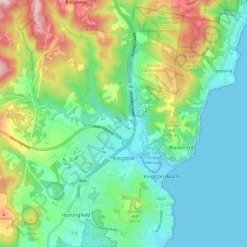
Name: Kingston topographic map, elevation, terrain.
Location: Kingston, Hobart, Kingborough, Tasmania, 7050, Australia (-43.00272 147.24451 -42.92599 147.33516)
Average elevation: 127 m
Minimum elevation: -1 m
Maximum elevation: 438 m
Tasmania trails, hiking, mountain biking, running and outdoor activities
Other topographic maps
Click on a map to view its topography, its elevation and its terrain.