
South Perth topographic map
Interactive map
Click on the map to display elevation.
About this map
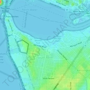
Name: South Perth topographic map, elevation, terrain.
Average elevation: 9 m
Minimum elevation: -1 m
Maximum elevation: 57 m
Other topographic maps
Click on a map to view its topography, its elevation and its terrain.
Waterford
Australia > Western Australia > City of South Perth
Waterford, City of South Perth, Western Australia, 6152, Australia
Average elevation: 8 m
Salter Point
Australia > Western Australia > City of South Perth
Salter Point, City of South Perth, Western Australia, 6152, Australia
Average elevation: 7 m
Como
Australia > Western Australia > City of South Perth
Como, City of South Perth, Western Australia, 6152, Australia
Average elevation: 12 m