
Bloomfield topographic map
Interactive map
Click on the map to display elevation.
About this map
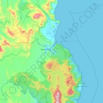
Name: Bloomfield topographic map, elevation, terrain.
Location: Bloomfield, Cook Shire, Queensland, Australia (-16.15346 145.06844 -15.75528 145.42791)
Average elevation: 220 m
Minimum elevation: 0 m
Maximum elevation: 1,297 m
Other topographic maps
Click on a map to view its topography, its elevation and its terrain.
Bloomfield
Australia > Queensland > Bloomfield
Bloomfield, Queensland, Australia
Average elevation: 81 m