
Ardahan topographic map
Interactive map
Click on the map to display elevation.
About this map
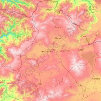
Name: Ardahan topographic map, elevation, terrain.
Location: Ardahan, Eastern Anatolia Region, Turkey (40.62917 42.31592 41.60027 43.47415)
Average elevation: 2,008 m
Minimum elevation: 665 m
Maximum elevation: 3,160 m
Ardahan province is located in the far north east of Turkey, where the eastern extremity of the high plateau of Eastern Anatolia converges with the Lesser Caucasus mountain range. It is consequently an area of very high altitude and severe winters. This is attractive open countryside which however spends many months of the year under snow. At this altitude temperatures on average reach −20 °C (−4 °F) and can drop below freezing all year round, including summer months.
Other topographic maps
Click on a map to view its topography, its elevation and its terrain.
Ballık
Ballık, Altınyayla, Burdur, Mediterranean Region, Turkey
Average elevation: 1,528 m
Bezirhane Mahallesi
Bezirhane Mahallesi, Gölbaşı, Ankara, Central Anatolia Region, Turkey
Average elevation: 1,158 m
Bıçakcılar
Bıçakcılar, Yusufeli, Artvin, Black Sea Region, Turkey
Average elevation: 1,833 m
Eskisehir
Eskisehir, Odunpazarı, Eskişehir, Central Anatolia Region, 26120, Turkey
Average elevation: 949 m
İshakçelebi
İshakçelebi, Saruhanlı, Manisa, Aegean Region, Turkey
Average elevation: 55 m
Akşemsettin Mahallesi
Akşemsettin Mahallesi, Eyüpsultan, Istanbul, Marmara Region, 34070, Turkey
Average elevation: 62 m
Camuzcu Mahallesi
Camuzcu Mahallesi, Seyhan, Adana, Mediterranean Region, Turkey
Average elevation: 13 m