
Make a donation
Gear up for your next adventure:
As an Amazon Associate, this site earns from qualifying purchases at no extra cost to you.
Townville topographic map
Click on the map to display elevation.
Make a donation
Gear up for your next adventure:
As an Amazon Associate, this site earns from qualifying purchases at no extra cost to you.
Townville
The borough is in a valley at the height of land between north-flowing Muddy Creek and south-flowing Sugar Creek, both tributaries of French Creek and part of the Allegheny River watershed. The lowest elevation in Townville is 1,370 ft (420 m) on the southern boundary at the wetland that is drained by Muddy Creek and Sugar Creek. The highest elevation is 1,500 ft (460 m) on the western boundary.
Make a donation
Gear up for your next adventure:
As an Amazon Associate, this site earns from qualifying purchases at no extra cost to you.
About this map
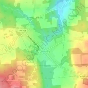
Name: Townville topographic map, elevation, terrain.
Average elevation: 450 m
Minimum elevation: 406 m
Maximum elevation: 501 m
Make a donation
Gear up for your next adventure:
As an Amazon Associate, this site earns from qualifying purchases at no extra cost to you.