
Thank you for supporting this site ❤️
Make a donation
Make a donation
Gear up for your next adventure:
As an Amazon Associate, this site earns from qualifying purchases at no extra cost to you.
Stanley topographic map
Click on the map to display elevation.
Thank you for supporting this site ❤️
Make a donation
Make a donation
Gear up for your next adventure:
As an Amazon Associate, this site earns from qualifying purchases at no extra cost to you.
About this map
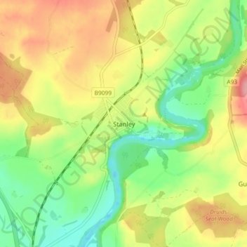
Name: Stanley topographic map, elevation, terrain.
Location: Stanley, Perth and Kinross, Scotland, PH1 4LY, United Kingdom (56.46119 -3.46664 56.50119 -3.42664)
Average elevation: 57 m
Minimum elevation: 7 m
Maximum elevation: 117 m
Thank you for supporting this site ❤️
Make a donation
Make a donation
Gear up for your next adventure:
As an Amazon Associate, this site earns from qualifying purchases at no extra cost to you.