
Changning topographic map
Interactive map
Click on the map to display elevation.
Changning
The topography of Changning is low in the south and high in the north, it is roughly a two-step staircase. Tashan Mountain (塔山) and Dayi Mountain (大义山) in the south of the city are clusters of Nanling Mountains, and the two mountains are in the north-east and north–south directions respectively. Between the two mountains is the Mianqian - Xihu Low Flat Valley (庙前-西湖低平谷地), which is the traffic channel between Changning and Guiyang. There are 16 peaks above 1000 meters above sea level and 63 between 1000 meters to 100 meters above sea level. These mountains form the natural barrier in the south and are the first step. The terrain in the north is undulating with the plains and hills staggered. Most of them are below 200 meters above sea level, it is the second step. The territory of Changning is divided into three types of terrain: mountainous area, hilly area and plain. The area of mountains, hilly area and plain respectively account for 37.6%, 26% and 37.4% of the total area of the city.
About this map
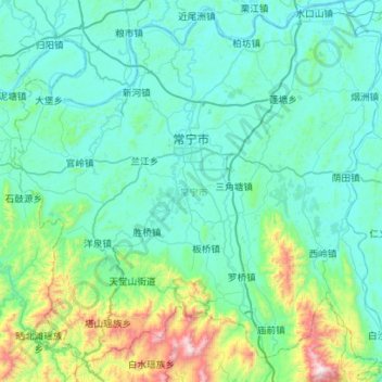
Name: Changning topographic map, elevation, terrain.
Location: Changning, Hengyang, Hunan, China (26.12310 112.13325 26.60417 112.68795)
Average elevation: 225 m
Minimum elevation: 47 m
Maximum elevation: 1,405 m