
Rutherglen topographic map
Interactive map
Click on the map to display elevation.
About this map
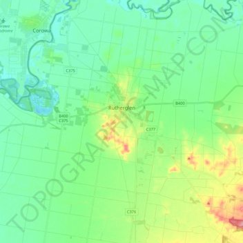
Name: Rutherglen topographic map, elevation, terrain.
Location: Rutherglen, Shire of Indigo, Victoria, 3685, Australia (-36.12160 146.37861 -36.00625 146.58975)
Average elevation: 158 m
Minimum elevation: 126 m
Maximum elevation: 248 m
Rutherglen features a mediterranean climate (Csa) with hot, dry summers and cool, damp winters. Climate data is sourced from Rutherglen Research; established in 1912 and still operating today. It is at an elevation of 175 metres (574 ft).