
Rhyndaston topographic map
Interactive map
Click on the map to display elevation.
About this map
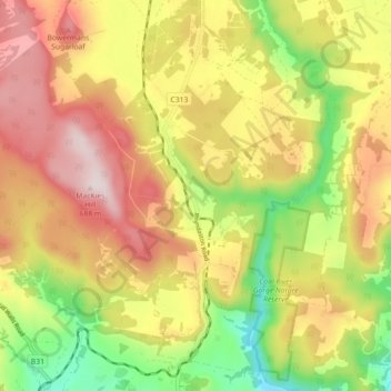
Name: Rhyndaston topographic map, elevation, terrain.
Location: Rhyndaston, Southern Midlands, Tasmania, Australia (-42.50553 147.32687 -42.44304 147.41637)
Average elevation: 445 m
Minimum elevation: 191 m
Maximum elevation: 685 m
Tasmania trails, hiking, mountain biking, running and outdoor activities