
Cortona topographic map
Interactive map
Click on the map to display elevation.
About this map
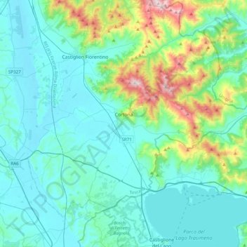
Name: Cortona topographic map, elevation, terrain.
Location: Cortona, Arezzo, Tuscany, 52044, Italy (43.15634 11.83351 43.37221 12.22465)
Average elevation: 375 m
Minimum elevation: 238 m
Maximum elevation: 1,063 m
The prevailing character of Cortona's architecture is medieval with steep narrow streets situated on a hillside at an elevation of 600 metres (2,000 ft) that embraces a view of the whole of the Valdichiana. From the Piazza Garibaldi (still referred to by the local population by its older name, Piazza Carbonaia) is a fine prospect of Lake Trasimeno, scene of Hannibal's ambush of the Roman army in 217 BC (Battle of Lake Trasimene). Parts of the Etruscan city wall can still be seen today as the basis of the present wall. The main street, via Nazionale, is the only street in the town with no gradient, and is still usually referred to by locals by its older name of Ruga Piana.