
Ledbury topographic map
Interactive map
Click on the map to display elevation.
About this map
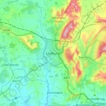
Name: Ledbury topographic map, elevation, terrain.
Average elevation: 88 m
Minimum elevation: 34 m
Maximum elevation: 232 m
Other topographic maps
Click on a map to view its topography, its elevation and its terrain.
Ryefield Coppice
United Kingdom > England > Ledbury
Ryefield Coppice, Ledbury, Herefordshire, West Midlands, England, United Kingdom
Average elevation: 76 m