
Charleroi topographic map
Interactive map
Click on the map to display elevation.
About this map
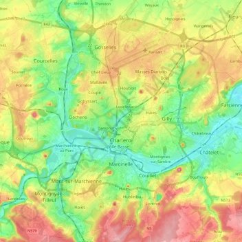
Name: Charleroi topographic map, elevation, terrain.
Location: Charleroi, Hainaut, Wallonia, Belgium (50.35284 4.34811 50.49243 4.50755)
Average elevation: 152 m
Minimum elevation: 92 m
Maximum elevation: 233 m
The topography of Charleroi is influenced by the valley of the river Sambre, which flows from west to east before joining the Meuse at Namur. The Piéton river flows from north to south to join the Sambre at Dampremy. The Charleroi-Brussels canal is dug in the valley of this stream. The Eau d'Heure river comes from the south and also flows into the Sambre at Marchienne-au-Pont. About twenty streams run through the territory of the municipality.
Other topographic maps
Click on a map to view its topography, its elevation and its terrain.