
Clyde topographic map
Interactive map
Click on the map to display elevation.
About this map
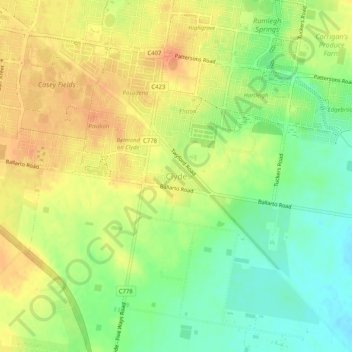
Name: Clyde topographic map, elevation, terrain.
Location: Clyde, City of Casey, Victoria, 3978, Australia (-38.15263 145.30904 -38.11263 145.34904)
Average elevation: 33 m
Minimum elevation: 9 m
Maximum elevation: 53 m
Other topographic maps
Click on a map to view its topography, its elevation and its terrain.
Hastings District
Australia > Victoria > Koo Wee Rup > Clyde
Hastings District, Rossiter Road, Koo Wee Rup, Shire of Cardinia, Victoria, 3981, Australia
Average elevation: 14 m