
Make a donation
Gear up for your next adventure:
As an Amazon Associate, this site earns from qualifying purchases at no extra cost to you.
Upton County topographic map
Click on the map to display elevation.
Make a donation
Gear up for your next adventure:
As an Amazon Associate, this site earns from qualifying purchases at no extra cost to you.
Upton County
According to the U.S. Census Bureau, the county has a total area of 1,242 square miles (3,220 km2), of which 1,241 square miles (3,210 km2) is land and 0.2 square miles (0.52 km2) (0.01%) is water. The Spraberry Trend, the third-largest oil field in the United States by remaining reserves, underlies much of the county. Bobcat Hills, a summit with an elevation of 2,697 ft (822 m), is found in Upton County.
Make a donation
Gear up for your next adventure:
As an Amazon Associate, this site earns from qualifying purchases at no extra cost to you.
About this map
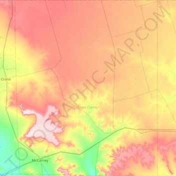
Name: Upton County topographic map, elevation, terrain.
Location: Upton County, Texas, United States (31.07976 -102.31789 31.65164 -101.77498)
Average elevation: 825 m
Minimum elevation: 695 m
Maximum elevation: 958 m
Make a donation
Gear up for your next adventure:
As an Amazon Associate, this site earns from qualifying purchases at no extra cost to you.