
Pakatoa Island topographic map
Interactive map
Click on the map to display elevation.
About this map
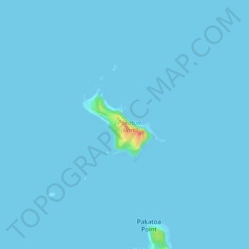
Name: Pakatoa Island topographic map, elevation, terrain.
Location: Pakatoa Island, Waiheke, Auckland, New Zealand (-36.80018 175.18896 -36.79170 175.20018)
Average elevation: 1 m
Minimum elevation: 0 m
Maximum elevation: 46 m
Other topographic maps
Click on a map to view its topography, its elevation and its terrain.
South Island
New Zealand > Auckland > Waiheke
South Island, Waiheke, Auckland, New Zealand
Average elevation: 4 m
Waiheke Island
New Zealand > Auckland > Waiheke
Waiheke Island, Waiheke, Auckland, New Zealand
Average elevation: 16 m