
Mitchell Island topographic map
Interactive map
Click on the map to display elevation.
About this map
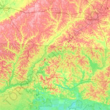
Name: Mitchell Island topographic map, elevation, terrain.
Location: Mitchell Island, Leon County, Florida, United States (30.30936 -84.55546 30.94936 -83.91546)
Average elevation: 52 m
Minimum elevation: 2 m
Maximum elevation: 107 m
Other topographic maps
Click on a map to view its topography, its elevation and its terrain.
Tallahassee
United States > Florida > Leon County
Tallahassee, Leon County, Florida, United States
Average elevation: 36 m
Alfred B. Maclay Gardens State Park
United States > Florida > Leon County > Tallahassee
Alfred B. Maclay Gardens State Park, 3540, Thomasville Road, Tallahassee, Leon County, Florida, 32309, United States
Average elevation: 58 m