Geolocate

Village of Scarsdale topographic map

Interactive map

Click on the map to display elevation.

About this map

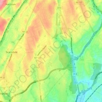
Name: Village of Scarsdale topographic map, elevation, terrain.

Location: Village of Scarsdale, Westchester County, New York, 10583, United States (40.95576 -73.81066 41.02194 -73.74458)

Average elevation: 76 m

Minimum elevation: 29 m

Maximum elevation: 134 m

Other topographic maps

Click on a map to view its topography, its elevation and its terrain.

Cecil Park

United States > New York > Westchester County > City of Yonkers

Cecil Park, City of Yonkers, Westchester County, New York, 10707, United States

Average elevation: 70 m

Chester Heights

United States > New York > Westchester County > City of New Rochelle

Chester Heights, City of New Rochelle, Westchester County, New York, 10801, United States

Average elevation: 36 m

City of White Plains

United States > New York > Westchester County

City of White Plains, Westchester County, New York, United States

Average elevation: 83 m

Village of Buchanan

United States > New York > Westchester County > Town of Cortlandt

Village of Buchanan, Town of Cortlandt, Westchester County, New York, 10511, United States

Average elevation: 28 m

Lincoln

United States > New York > Westchester County > City of Yonkers

Lincoln, City of Yonkers, Westchester County, New York, 10705, United States

Average elevation: 49 m

Town of Mount Pleasant

United States > New York > Westchester County > Town of Mount Pleasant

Town of Mount Pleasant, Westchester County, New York, United States

Average elevation: 95 m

Village of Ossining

United States > New York > Westchester County

Village of Ossining, Town of Ossining, Westchester County, New York, 10562, United States

Average elevation: 61 m

Yonkers

United States > New York > Westchester County > Yonkers

Yonkers, Westchester County, New York, United States

Average elevation: 58 m