
Waubaushene topographic map
Interactive map
Click on the map to display elevation.
About this map
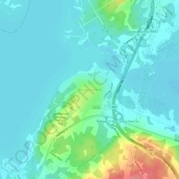
Name: Waubaushene topographic map, elevation, terrain.
Average elevation: 188 m
Minimum elevation: 172 m
Maximum elevation: 253 m
Other topographic maps
Click on a map to view its topography, its elevation and its terrain.
Victoria Harbour
Canada > Ontario > Simcoe County > Tay
Victoria Harbour, Tay, Simcoe County, Central Ontario, Ontario, L0K 2A0, Canada
Average elevation: 185 m
Port McNicoll
Canada > Ontario > Simcoe County > Tay
Port McNicoll, Tay, Simcoe County, Central Ontario, Ontario, L0K 1R0, Canada
Average elevation: 191 m