
Le Havre topographic map
Interactive map
Click on the map to display elevation.
About this map
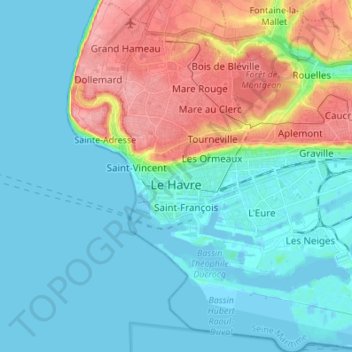
Name: Le Havre topographic map, elevation, terrain.
Location: Le Havre, Seine-Maritime, Normandy, Metropolitan France, France (49.45167 0.06680 49.54015 0.19556)
Average elevation: 27 m
Minimum elevation: -5 m
Maximum elevation: 102 m
Other topographic maps
Click on a map to view its topography, its elevation and its terrain.
Norville
France > Normandy > Seine-Maritime
Norville, Le Havre, Seine-Maritime, Normandy, Metropolitan France, 76330, France
Average elevation: 46 m
Eu
France > Normandy > Seine-Maritime
Eu, Dieppe, Seine-Maritime, Normandy, Metropolitan France, 76260, France
Average elevation: 63 m
La Bouille
France > Normandy > Seine-Maritime > La Bouille
La Bouille, Rouen, Seine-Maritime, Normandy, Metropolitan France, 76530, France
Average elevation: 64 m
Bully
France > Normandy > Seine-Maritime
Bully, Dieppe, Seine-Maritime, Normandy, Metropolitan France, 76270, France
Average elevation: 160 m
Normanville
France > Normandy > Seine-Maritime
Normanville, Dieppe, Seine-Maritime, Normandy, Metropolitan France, 76640, France
Average elevation: 124 m
Néville
France > Normandy > Seine-Maritime
Néville, Dieppe, Seine-Maritime, Normandy, Metropolitan France, 76460, France
Average elevation: 71 m
Montville
France > Normandy > Seine-Maritime
Montville, Rouen, Seine-Maritime, Normandy, Metropolitan France, 76710, France
Average elevation: 123 m