
Dampier topographic map
Interactive map
Click on the map to display elevation.
About this map
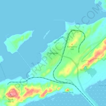
Name: Dampier topographic map, elevation, terrain.
Location: Dampier, Western Australia, 6713, Australia (-20.70248 116.67190 -20.62248 116.75190)
Average elevation: 15 m
Minimum elevation: -2 m
Maximum elevation: 107 m
Other topographic maps
Click on a map to view its topography, its elevation and its terrain.
Dampier
Australia > Western Australia > Dampier
Dampier, City Of Karratha, Western Australia, 6713, Australia
Average elevation: 20 m