
Marrangaroo National Park topographic map
Interactive map
Click on the map to display elevation.
About this map
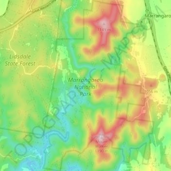
Name: Marrangaroo National Park topographic map, elevation, terrain.
Average elevation: 933 m
Minimum elevation: 777 m
Maximum elevation: 1,162 m
Other topographic maps
Click on a map to view its topography, its elevation and its terrain.
Lake Lyell
Australia > New South Wales > Lyells Crossing
Lake Lyell, Sir Thomas Mitchell Drive, South Bowenfels, Lyells Crossing, Lithgow City Council, New South Wales, 2790, Australia
Average elevation: 865 m