
Echt-Susteren topographic map
Interactive map
Click on the map to display elevation.
Echt-Susteren
Dutch Topographic map of the municipality of Echt-Susteren, June 2015
About this map
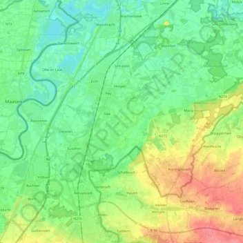
Name: Echt-Susteren topographic map, elevation, terrain.
Location: Echt-Susteren, Limburg, Netherlands (51.02834 5.79511 51.13596 6.03649)
Average elevation: 38 m
Minimum elevation: 16 m
Maximum elevation: 82 m
Other topographic maps
Click on a map to view its topography, its elevation and its terrain.