
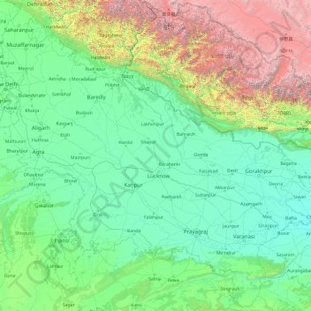
Uttar Pradesh topographic map
Interactive map
Click on the map to display elevation.
About this map
Name: Uttar Pradesh topographic map, elevation, terrain.
Location: Uttar Pradesh, India (23.87063 77.08388 30.40638 84.63451)
Average elevation: 954 m
Minimum elevation: 47 m
Maximum elevation: 7,878 m
Uttar Pradesh, with a total area of 243,290 square kilometres (93,935 sq mi), is India's fourth-largest state in terms of land area and is roughly of same size as United Kingdom. It is situated on the northern spout of India and shares an international boundary with Nepal. The Himalayas border the state on the north, but the plains that cover most of the state are distinctly different from those high mountains. The larger Gangetic Plain region is in the north; it includes the Ganges-Yamuna Doab, the Ghaghra plains, the Ganges plains and the Terai. The smaller Vindhya Range and plateau region are in the south. It is characterised by hard rock strata and a varied topography of hills, plains, valleys and plateaus. The Bhabhar tract gives place to the terai area which is covered with tall elephant grass and thick forests interspersed with marshes and swamps. The sluggish rivers of the bhabhar deepen in this area, their course running through a tangled mass of thick undergrowth. The terai runs parallel to the bhabhar in a thin strip. The entire alluvial plain is divided into three sub-regions. The first in the eastern tract consisting of 14 districts which are subject to periodical floods and droughts and have been classified as scarcity areas. These districts have the highest density of population which gives the lowest per capita land. The other two regions, the central and the western, are comparatively better with a well-developed irrigation system. They suffer from waterlogging and large-scale user tracts. In addition, the area is fairly arid. The state has more than 32 large and small rivers; of them, the Ganga, Yamuna, Saraswati, Sarayu, Betwa, and Ghaghara are larger and of religious importance in Hinduism.
Other topographic maps
Click on a map to view its topography, its elevation and its terrain.
Coimbatore
India > Tamil Nadu > Coimbatore North
Coimbatore, Coimbatore North, Coimbatore District, Tamil Nadu, 641001, India
Average elevation: 452 m
Lucknow
India > Uttar Pradesh > Lucknow
Lucknow, Lucknow District, Uttar Pradesh, 226027, India
Average elevation: 120 m
Dharamshala
India > Himachal Pradesh > Dharamshala
Dharamshala, Kangra District, Himachal Pradesh, 176200, India
Average elevation: 1,781 m
Mohali
India > Madhya Pradesh > Rehli Tahsil
Mohali, Rehli Tahsil, Sagar District, Madhya Pradesh, India
Average elevation: 430 m
Kashipur
India > Uttarakhand > Kashipur
Kashipur, Udham Singh Nagar District, Uttarakhand, 244713, India
Average elevation: 233 m
Dharav Parav
India > Madhya Pradesh > Bankhedi Tahsil
Dharav Parav, Bankhedi Tahsil, Narmadapuram District, Madhya Pradesh, India
Average elevation: 378 m
Bhagsu
India > Himachal Pradesh > Dharamshala
Bhagsu, Dharamshala, Kangra District, Himachal Pradesh, 176219, India
Average elevation: 1,955 m
Tholpetty
India > Kerala > Mananthavady
Tholpetty, Mananthavady, Wayanad District, Kerala, 571250, India
Average elevation: 875 m
Rampura
India > Gujarat > Detroj Rampura Taluka
Rampura, Detroj Rampura Taluka, Ahmedabad District, Gujarat, 382140, India
Average elevation: 42 m
Dantiwada dam
India > Gujarat > Dantiwada Taluka > Dantiwada
Dantiwada dam, Dantiwada, Dantiwada Taluka, Banaskantha District, Gujarat, 385505, India
Average elevation: 170 m
Gullah
India > Punjab > Guruharsahai Tahsil
Gullah, Guruharsahai Tahsil, Firozpur District, Punjab, 152024, India
Average elevation: 187 m
Machilipatnam
India > Andhra Pradesh > Machilipatnam
Machilipatnam, Krishna, Andhra Pradesh, 521001, India
Average elevation: 4 m
Thrikkunnapuzha
India > Kerala > Karthikappally
Thrikkunnapuzha, Karthikappally, Alappuzha District, Kerala, 690516, India
Average elevation: 2 m
Jaipur
India > Rajasthan > Jaipur Tehsil
Jaipur, Jaipur Municipal Corporation, Jaipur Tehsil, Jaipur, Rajasthan, 302001, India
Average elevation: 408 m
Maranda
India > Madhya Pradesh > Baihar Tahsil
Maranda, Baihar Tahsil, Balaghat District, Madhya Pradesh, India
Average elevation: 641 m
Waruda
India > Maharashtra > Teosa
Waruda, Teosa, Amravati, Maharashtra, India
Average elevation: 335 m
Mundi
India > Madhya Pradesh > Damoh Tahsil
Mundi, Damoh Tahsil, Damoh District, Madhya Pradesh, India
Average elevation: 364 m
Galore
Galore, Hamirpur District, Himachal Pradesh, 177006, India
Average elevation: 693 m
Suryapet
India > Telangana > Suryapet mandal
Suryapet, Suryapet mandal, Suryapet District, Telangana, 508213, India
Average elevation: 180 m
Vallapuzha
Vallapuzha, Pattambi, Palakkad District, Kerala, 679335, India
Average elevation: 56 m
Jaynagar - I
Jaynagar - I, South 24 Parganas District, West Bengal, India
Average elevation: 4 m
Bargara
India > Madhya Pradesh > Chitrangi Tahsil
Bargara, Chitrangi Tahsil, Singrauli District, Madhya Pradesh, India
Average elevation: 211 m
Kerla
India > Rajasthan > Pali Tehsil
Kerla, Pali Tehsil, Pali District, Rajasthan, India
Average elevation: 199 m
Rajkot
India > Gujarat > Rajkot East Taluka
Rajkot, Rajkot East Taluka, Rajkot District, Gujarat, 360001, India
Average elevation: 141 m
Bering
India > Punjab > Mukerian Tahsil
Bering, Mukerian Tahsil, Hoshiarpur District, Punjab, 144223, India
Average elevation: 622 m
Papan
India > Madhya Pradesh > Seoni-Malwa Tahsil
Papan, Seoni-Malwa Tahsil, Narmadapuram District, Madhya Pradesh, India
Average elevation: 281 m
Puducherry
India > Puducherry > Puducherry Taluk
Puducherry, Puducherry Taluk, Puducherry District, Puducherry, 605001, India
Average elevation: 10 m
Malak
India > Punjab > Kharar Tahsil
Malak, Kharar Tahsil, Sahibzada Ajit Singh Nagar District, Punjab, 140901, India
Average elevation: 352 m
Tharwa
India > Madhya Pradesh > Harrai Tahsil
Tharwa, Harrai Tahsil, Chhindwara District, Madhya Pradesh, India
Average elevation: 644 m
Sukma
India > Chhattisgarh > Sukma Tahsil
Sukma, Sukma Tahsil, Sukma District, Chhattisgarh, 494111, India
Average elevation: 219 m
Sullurpeta
India > Andhra Pradesh > Sullurpeta
Sullurpeta, Tirupati District, Andhra Pradesh, 524121, India
Average elevation: 4 m
Para River
India > Haryana > Siwan > KACHI PISOL
Para River, KACHI PISOL, Siwan, Kaithal District, Haryana, 136033, India
Average elevation: 235 m
Thiruvallur
Thiruvallur, Thiruvallur District, Tamil Nadu, India
Average elevation: 50 m