
Serra da Mantiqueira topographic map
Interactive map
Click on the map to display elevation.
About this map
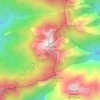
Name: Serra da Mantiqueira topographic map, elevation, terrain.
Average elevation: 2,271 m
Minimum elevation: 1,883 m
Maximum elevation: 2,634 m
The Serra da Mantiqueira is a part of the Atlantic Forest ecosystem. Despite the clearing of the land for livestock raising, the difficult access to many areas has made possible for sanctuaries of well-preserved forest to still exist, with trees such as the jacarandá, Spanish cedar, canjerana, guatambu, ipê, canela, angico, jequitibá, and also the araucaria, more typical of subtropical South America but found in the area because of altitude. At its closest point, the region is only 100 km (62 mi) from the city of São Paulo.