
Tioman Island topographic map
Interactive map
Click on the map to display elevation.
Tioman Island
Local mythology claims that the island is the embodiment of the mighty dragon Sri Gumom. The dragon was on his way to visit his sister Gunung Linga (Lingin Peak) but the great Sri Rama forbade the meeting and Sri Gumom was turned into a stone and fell into the deep sea where he now remains, frozen in eternity as this beautiful island with its distinctive topography.
About this map
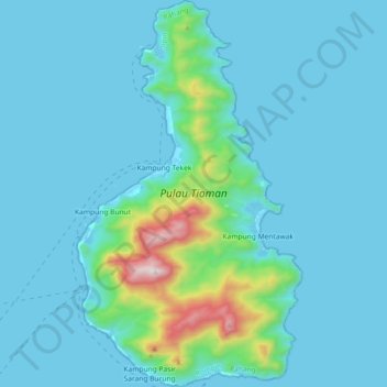
Name: Tioman Island topographic map, elevation, terrain.
Location: Tioman Island, Rompin, Malaysia (2.71550 104.11721 2.89731 104.22327)
Average elevation: 104 m
Minimum elevation: -1 m
Maximum elevation: 1,003 m
Other topographic maps
Click on a map to view its topography, its elevation and its terrain.