
Port Campbell National Park topographic map
Interactive map
Click on the map to display elevation.
About this map
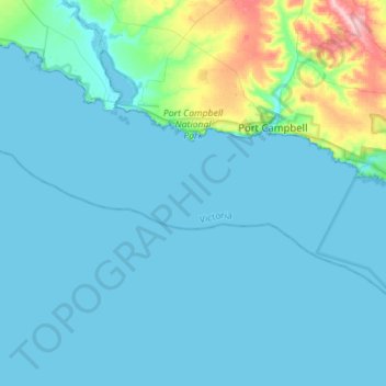
Name: Port Campbell National Park topographic map, elevation, terrain.
Location: Port Campbell National Park, Victoria, Australia (-38.70717 142.87820 -38.60620 143.15868)
Average elevation: 18 m
Minimum elevation: -1 m
Maximum elevation: 161 m
Other topographic maps
Click on a map to view its topography, its elevation and its terrain.
Castlemaine
Castlemaine, Shire of Mount Alexander, Victoria, 3450, Australia
Average elevation: 319 m
Lake Glenmaggie
Lake Glenmaggie, Glenmaggie, Shire of Wellington, Victoria, Australia
Average elevation: 98 m
Phillip Island
Australia > Victoria > Ventnor
Phillip Island, Ventnor, Bass Coast Shire, Victoria, Australia
Average elevation: 5 m
Yarra Ranges National Park
Australia > Victoria > Melbourne
Yarra Ranges National Park, Reefton, Melbourne, Shire of Yarra Ranges, Victoria, Australia
Average elevation: 465 m
North Wangaratta
North Wangaratta, Rural City of Wangaratta, Victoria, 3678, Australia
Average elevation: 148 m
Mount Eliza
Australia > Victoria > Melbourne
Mount Eliza, Melbourne, Shire of Mornington Peninsula, Victoria, 3930, Australia
Average elevation: 60 m
Mount Martha
Australia > Victoria > Melbourne
Mount Martha, Melbourne, Shire of Mornington Peninsula, Victoria, 3934, Australia
Average elevation: 40 m
Mornington District
Australia > Victoria > Melbourne
Mornington District, Melbourne, Shire of Mornington Peninsula, Victoria, Australia
Average elevation: 50 m
Eltham District
Australia > Victoria > Greensborough
Eltham District, Greensborough, City of Banyule, Victoria, Australia
Average elevation: 85 m
Melbourne District
Australia > Victoria > Melbourne
Melbourne District, Melbourne, City of Melbourne, Victoria, Australia
Average elevation: 20 m
Glen Waverley
Glen Waverley, City of Monash, Victoria, 3150, Australia
Average elevation: 103 m
Grampians National Park
Grampians National Park, Bellfield, Shire of Northern Grampians, Victoria, Australia
Average elevation: 262 m
Wilsons Promontory National Park
Wilsons Promontory National Park, Victoria, Australia
Average elevation: 32 m
Yarra Valley
Australia > Victoria > Melbourne
Yarra Valley, Melbourne, Shire of Yarra Ranges, Victoria, Australia
Average elevation: 305 m
Division of Kooyong
Australia > Victoria > Melbourne
Division of Kooyong, Melbourne, City of Boroondara, Victoria, Australia
Average elevation: 55 m
Kingsville
Australia > Victoria > Melbourne
Kingsville, Melbourne, City of Maribyrnong, Victoria, 3012, Australia
Average elevation: 23 m
Ocean Grove
Australia > Victoria > Ocean Grove
Ocean Grove, City of Greater Geelong, Victoria, 3226, Australia
Average elevation: 16 m
Great Otway National Park
Great Otway National Park, Victoria, Australia
Average elevation: 91 m
Warrnambool
Warrnambool, City of Warrnambool, Victoria, 3280, Australia
Average elevation: 19 m
Bells Beach
Bells Beach, Surf Coast Shire, Victoria, 3228, Australia
Average elevation: 55 m
Merricks North
Australia > Victoria > Melbourne
Merricks North, Melbourne, Shire of Mornington Peninsula, Victoria, 3926, Australia
Average elevation: 100 m
Shepparton District
Australia > Victoria > Shepparton
Shepparton District, Currawa Rise, Dookie, Shepparton, City of Greater Shepparton, Hume, Victoria, 3630, Australia
Average elevation: 113 m
Yackandandah
Australia > Victoria > Yackandandah
Yackandandah, Shire of Indigo, Hume, Victoria, 3749, Australia
Average elevation: 500 m
Eurobin Streamside Reserve
Eurobin Streamside Reserve, Great Alpine Road, Eurobin, Ovens, Alpine Shire, Victoria, 3739, Australia
Average elevation: 304 m