
San Salvador topographic map
Interactive map
Click on the map to display elevation.
About this map
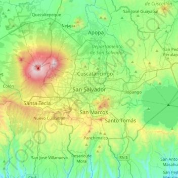
Name: San Salvador topographic map, elevation, terrain.
Average elevation: 647 m
Minimum elevation: 146 m
Maximum elevation: 1,930 m
The city is located in the Boquerón Volcano Valley, a region of high seismic activity. The city's average elevation is 659 metres (2,162 feet) above sea level, but ranges from a highest point of 1,186 metres (3,891 feet) above sea level to a lowest point of 596 m (1,955 ft) above sea level. The municipality is surrounded by these natural features of the landscape: southward by the Cordillera del Balsamo (Balsam Mountain Range); westward by the Boquerón Volcano and Cerro El Picacho, the highest point in the municipality at 1,929 m (6,329 ft). El Boquerón Volcano was dormant since its last eruption in 1917, but has been active recently. East of the municipality lies the San Jacinto Hill and the caldera of Lake Ilopango, the largest natural body of water in the country with an area of 72 square kilometres (28 square miles). The caldera is seismically active, but has not erupted since 1880.