
Loches topographic map
Interactive map
Click on the map to display elevation.
About this map
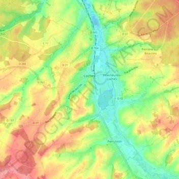
Name: Loches topographic map, elevation, terrain.
Average elevation: 106 m
Minimum elevation: 62 m
Maximum elevation: 152 m
Other topographic maps
Click on a map to view its topography, its elevation and its terrain.
L'Esperance
France > Centre-Val de Loire > Indre-et-Loire > Nouzilly
L'Esperance, Nouzilly, Loches, Indre-et-Loire, Centre-Val de Loire, Metropolitan France, 37380, France
Average elevation: 115 m
Tours
France > Centre-Val de Loire > Indre-et-Loire
Tours, Arrondissement de Tours, Indre-et-Loire, Centre-Val de Loire, Metropolitan France, France
Average elevation: 73 m