
Make a donation
Gear up for your next adventure:
As an Amazon Associate, this site earns from qualifying purchases at no extra cost to you.
Mount Ruapehu topographic map
Click on the map to display elevation.
Make a donation
Gear up for your next adventure:
As an Amazon Associate, this site earns from qualifying purchases at no extra cost to you.
Mount Ruapehu
Ruapehu has a polar tundra climate (Köppen: ET) on the upper slopes, with average temperatures ranging from −4–15 °C in summer and −7–7 °C in winter, depending on elevation and cloudiness. On the lower slopes, Ruapehu has a subpolar oceanic climate (Köppen: Cfc).
Make a donation
Gear up for your next adventure:
As an Amazon Associate, this site earns from qualifying purchases at no extra cost to you.
About this map
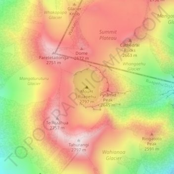
Name: Mount Ruapehu topographic map, elevation, terrain.
Average elevation: 2,474 m
Minimum elevation: 2,077 m
Maximum elevation: 2,755 m
Make a donation
Gear up for your next adventure:
As an Amazon Associate, this site earns from qualifying purchases at no extra cost to you.