
Mount Ruapehu topographic map
Interactive map
Click on the map to display elevation.
Mount Ruapehu
Ruapehu has a polar tundra climate (Köppen: ET) on the upper slopes, with average temperatures ranging from −4–15 °C in summer and −7–7 °C in winter, depending on elevation and cloudiness. On the lower slopes, Ruapehu has a subpolar oceanic climate (Köppen: Cfc).
About this map
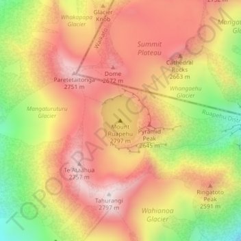
Name: Mount Ruapehu topographic map, elevation, terrain.
Average elevation: 2,474 m
Minimum elevation: 2,077 m
Maximum elevation: 2,755 m
Other topographic maps
Click on a map to view its topography, its elevation and its terrain.
Tongariro National Park
New Zealand > Manawatu-Whanganui > Ruapehu District
Like the whole of New Zealand, Tongariro National Park is situated in a temperate zone. The prevailing westerly winds gather water over the Tasman Sea. As the volcanoes of Tongariro National Park are the first significant elevations that these winds encounter on the North Island, besides Mount Taranaki, rain…
Average elevation: 888 m