
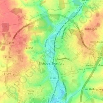
Bishop's Stortford topographic map
Interactive map
Click on the map to display elevation.
About this map
Name: Bishop's Stortford topographic map, elevation, terrain.
Average elevation: 83 m
Minimum elevation: 52 m
Maximum elevation: 111 m
Stortford, along with the rest of Britain, has a temperate maritime climate, with cool summers and mild winters. The nearest weather station for which averages and extremes are available is Stansted Airport, about .mw-parser-output .frac{white-space:nowrap}.mw-parser-output .frac .num,.mw-parser-output .frac .den{font-size:80%;line-height:0;vertical-align:super}.mw-parser-output .frac .den{vertical-align:sub}.mw-parser-output .sr-only{border:0;clip:rect(0,0,0,0);height:1px;margin:-1px;overflow:hidden;padding:0;position:absolute;width:1px}2+1⁄2 miles (4 kilometres) due east of Stortford's town centre. Located at an elevation of over 100 m, the weather station, and parts of Stortford in general are marginally cooler throughout the year than the Cambridgeshire area to the north or the London area to the south. Nonetheless, Stortford is still warmer than the English average.
Other topographic maps
Click on a map to view its topography, its elevation and its terrain.
Gilston
United Kingdom > England > Hertfordshire > East Hertfordshire > Gilston
Gilston, East Hertfordshire, Hertfordshire, England, United Kingdom
Average elevation: 59 m
Wakeley
United Kingdom > England > Hertfordshire > East Hertfordshire > Buntingford > Westmill > Wakeley
Wakeley, Westmill, Buntingford, East Hertfordshire, Hertfordshire, East of England, England, SG9 9NH, United Kingdom
Average elevation: 121 m