
Yarra River topographic map
Interactive map
Click on the map to display elevation.
About this map
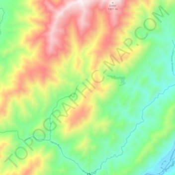
Name: Yarra River topographic map, elevation, terrain.
Location: Yarra River, Marlborough, New Zealand (-42.28898 172.97277 -42.21103 173.06363)
Average elevation: 1,233 m
Minimum elevation: 766 m
Maximum elevation: 1,921 m
Other topographic maps
Click on a map to view its topography, its elevation and its terrain.
Rousehill Reserve
New Zealand > Marlborough > Renwick
Rousehill Reserve, Renwick, Marlborough, New Zealand
Average elevation: 43 m
Seddon
New Zealand > Marlborough > Seddon
Seddon, Marlborough, 7210, New Zealand
Average elevation: 96 m
Duncan Bay
New Zealand > Marlborough > Duncan Bay
Duncan Bay, Marlborough, New Zealand
Average elevation: 173 m
Mount Richmond
Mount Richmond, Marlborough, New Zealand
Average elevation: 1,262 m