Geolocate

Nashua topographic map

Interactive map

Click on the map to display elevation.

About this map

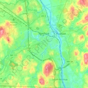
Name: Nashua topographic map, elevation, terrain.

Location: Nashua, Hillsborough County, New Hampshire, United States (42.69987 -71.56139 42.80586 -71.43229)

Average elevation: 62 m

Minimum elevation: 26 m

Maximum elevation: 135 m

Other topographic maps

Click on a map to view its topography, its elevation and its terrain.

Thorntons Ferry

United States > New Hampshire > Hillsborough County > Merrimack

Thorntons Ferry, Merrimack, Hillsborough County, New Hampshire, 03054, United States

Average elevation: 54 m

Hollis

United States > New Hampshire > Hillsborough County

Hollis, Hillsborough County, New Hampshire, United States

Average elevation: 101 m

Manchester

United States > New Hampshire > Hillsborough County

Manchester, Hillsborough County, New Hampshire, United States

Average elevation: 96 m

Amherst

United States > New Hampshire > Hillsborough County > Amherst

Amherst, Hillsborough County, New Hampshire, 03031, United States

Average elevation: 127 m

Nashua

United States > New Hampshire > Hillsborough County > Nashua

Nashua, Hillsborough County, New Hampshire, 03060-03064, United States

Average elevation: 82 m