
Raymond Island topographic map
Interactive map
Click on the map to display elevation.
About this map
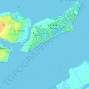
Name: Raymond Island topographic map, elevation, terrain.
Average elevation: 2 m
Minimum elevation: -3 m
Maximum elevation: 28 m
Other topographic maps
Click on a map to view its topography, its elevation and its terrain.
Steel Bay - Newland Backwater Gippsland Lakes Reserve
Australia > Victoria > Paynesville
Steel Bay - Newland Backwater Gippsland Lakes Reserve, Goon Nure, Paynesville, Shire of East Gippsland, Victoria, Australia
Average elevation: 17 m
Paynesville
Australia > Victoria > Paynesville
Paynesville, Shire of East Gippsland, Victoria, 3880, Australia
Average elevation: 5 m