
High Fields topographic map
Interactive map
Click on the map to display elevation.
About this map
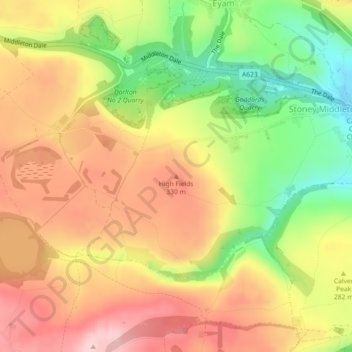
Name: High Fields topographic map, elevation, terrain.
Average elevation: 280 m
Minimum elevation: 155 m
Maximum elevation: 383 m
Other topographic maps
Click on a map to view its topography, its elevation and its terrain.
Peak District National Park
United Kingdom > England > Derbyshire Dales
Peak District National Park, Brough lane, Abney and Abney Grange CP, Derbyshire Dales, Derbyshire, East Midlands, England, S33 9HZ, United Kingdom
Average elevation: 225 m
Ashbourne
United Kingdom > England > Derbyshire Dales > Ashbourne
Ashbourne, Derbyshire Dales, Derbyshire, East Midlands, England, DE6 1FG, United Kingdom
Average elevation: 172 m