
Langford topographic map
Interactive map
Click on the map to display elevation.
About this map
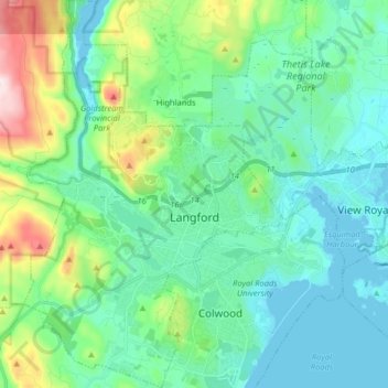
Name: Langford topographic map, elevation, terrain.
Average elevation: 116 m
Minimum elevation: -1 m
Maximum elevation: 541 m
Other topographic maps
Click on a map to view its topography, its elevation and its terrain.
Rockhampton Park
Canada > British Columbia > Langford
Rockhampton Park, Bear Mountain, Langford, Capital Regional District, British Columbia, Canada
Average elevation: 176 m