
Make a donation
Brittany topographic map
Click on the map to display elevation.
Make a donation
About this map
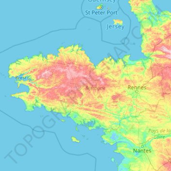
Name: Brittany topographic map, elevation, terrain.
Location: Brittany, Metropolitan France, France (47.27776 -5.14403 49.11330 -1.01569)
Average elevation: 41 m
Minimum elevation: -3 m
Maximum elevation: 365 m
Make a donation
Other topographic maps
Click on a map to view its topography, its elevation and its terrain.
Make a donation
Mont Blanc / Monte Bianco
France > Auvergne-Rhône-Alpes > Upper Savoy > Chamonix-Mont-Blanc
The climate is cold and temperate (Köppen climate classification Cfb), and is greatly influenced by altitude. Being the highest part of the Alps, Mont Blanc and surrounding mountains can create their own weather patterns. Temperatures drop as the mountains gain in height, and the summit of Mont Blanc is a…
Average elevation: 4,092 m
Make a donation
Les Résidences
France > Auvergne-Rhône-Alpes > Puy-de-Dôme > Murat-le-Quaire
Average elevation: 1,072 m
Siaugues-Saint-Romain
France > Auvergne-Rhône-Alpes > Haute-Loire > Siaugues-Sainte-Marie
Average elevation: 951 m
Make a donation
Make a donation
Make a donation
Make a donation
Les Baux
France > Pays de la Loire > Loire-Atlantique > Vair-sur-Loire > Saint-Herblon
Average elevation: 50 m
Make a donation
Tré-le-Champ - le Haut
France > Auvergne-Rhône-Alpes > Upper Savoy > Chamonix-Mont-Blanc
Average elevation: 1,737 m
Aix-en-Provence
France > Provence-Alpes-Côte d'Azur > Bouches-du-Rhône > Aix-en-Provence
Average elevation: 279 m
La Grave de Peille
France > Provence-Alpes-Côte d'Azur > Maritime Alps > Peille
Average elevation: 400 m
Make a donation
Make a donation
Le Revest-les-Eaux
France > Provence-Alpes-Côte d'Azur > Var > Le Revest-les-Eaux > Le Revest-les-Eaux
Average elevation: 327 m
Make a donation
La Teste-de-Buch
France > New Aquitaine > Gironde > La Teste-de-Buch > La Teste-de-Buch
Average elevation: 12 m
Le Tour
France > Auvergne-Rhône-Alpes > Upper Savoy > Chamonix-Mont-Blanc > Le Tour
Average elevation: 1,811 m
Make a donation
La Maranche
France > Auvergne-Rhône-Alpes > Loire > Saint-Bonnet-le-Courreau > La Maranche
Average elevation: 894 m
Make a donation
Make a donation
Make a donation
Sur la Roche
France > Auvergne-Rhône-Alpes > Saint-Julien-Mont-Denis > Sur la Roche
Average elevation: 1,872 m
Make a donation
Make a donation
La Chaigne
France > Bourgogne-Franche-Comté > Beaurepaire-en-Bresse > La Chaigne
Average elevation: 211 m
Make a donation
Tré-le-Champ - le Bas
France > Auvergne-Rhône-Alpes > Upper Savoy > Chamonix-Mont-Blanc > Tré-le-Champ - le Bas
Average elevation: 1,724 m
Make a donation
Le Planet
France > Auvergne-Rhône-Alpes > Chamonix-Mont-Blanc > Argentière > Le Planet
Average elevation: 1,672 m
Make a donation
Paris
Paris in its early history had only the rivers Seine and Bièvre for water. From 1809, the Canal de l'Ourcq provided Paris with water from less-polluted rivers to the north-east of the capital. From 1857, the civil engineer Eugène Belgrand, under Napoleon III, oversaw the construction of a series of new…
Average elevation: 75 m
Make a donation