
Chiang Rai topographic map
Interactive map
Click on the map to display elevation.
About this map
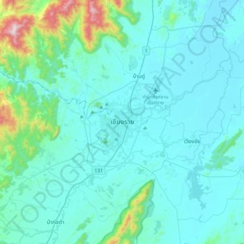
Name: Chiang Rai topographic map, elevation, terrain.
Location: Chiang Rai, Tha Sai, Chiang Rai Province, 57000, Thailand (19.74689 99.67327 20.06689 99.99327)
Average elevation: 473 m
Minimum elevation: 374 m
Maximum elevation: 1,313 m
Other topographic maps
Click on a map to view its topography, its elevation and its terrain.
Ban Rai
Thailand > Chiang Rai Province > Chiang Saen district
Ban Rai, Chiang Saen district, Mae Ngoen, Chiang Rai Province, Thailand
Average elevation: 412 m
Yang Hom
Thailand > Chiang Rai Province > Yang Hom
Yang Hom, Chiang Rai Province, Thailand
Average elevation: 467 m
Ban Pong Sali
Thailand > Chiang Rai Province > Ban Pong Sali
Ban Pong Sali, Chiang Rai Province, Thailand
Average elevation: 406 m